


Dayton, Marengo County, Alabama
About
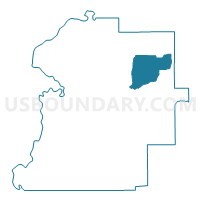
Outline

Summary
| Unique Area Identifier | 522430 |
| Name | Dayton |
| County | Marengo County |
| State | Alabama |
| Area (square miles) | 41.01 |
| Land Area (square miles) | 40.98 |
| Water Area (square miles) | 0.03 |
| % of Land Area | 99.92 |
| % of Water Area | 0.08 |
| Latitude of the Internal Point | 32.36397660 |
| Longtitude of the Internal Point | -87.62582860 |
Maps


Graphs
Select a template below for downloading or customizing gragh for Dayton, Marengo County, Alabama


Neighbors
Neighoring Voting District (by Name) Neighboring Voting District on the Map
- Faunsdale, Marengo County, AL
- Taylorville Voting Booth, Marengo County, AL
- Thomaston, Marengo County, AL
- VFW, Marengo County, AL
Top 10 Neighboring County Subdivision (by Population) Neighboring County Subdivision on the Map
- Linden CCD, Marengo County, AL (4,762)
- Thomaston CCD, Marengo County, AL (1,368)
- Faunsdale CCD, Marengo County, AL (782)